Monticello sits in the hill country of Drew County, on what the National Register files call the Monticello Ridge. When the county was created in 1846, its court first met in a home and then at a school in Rough and Ready, a hilltop village about a mile south of today’s downtown. A few years later the county laid out a new seat around a courthouse square. The town’s name is said to honor Thomas Jefferson’s home in Virginia.
The railroad reached Monticello in the 1880s. In 1910 the state opened an agricultural school here that grew into the University of Arkansas at Monticello, and in 1932 a new courthouse went up on South Main Street. This page collects dated photos, maps and public records from that history, with a link to every source.
Then and now
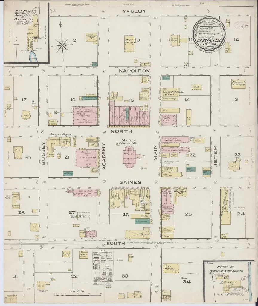
Then, 1886
Now, 2014


In 1886 the county’s brick courthouse, built in 1870 and 1871, stood in the middle of the square, ringed by stores. It was torn down in 1932, when the new courthouse opened two blocks south on Main Street. The old square has been an open public space ever since and is now a small park.
Maps through the years
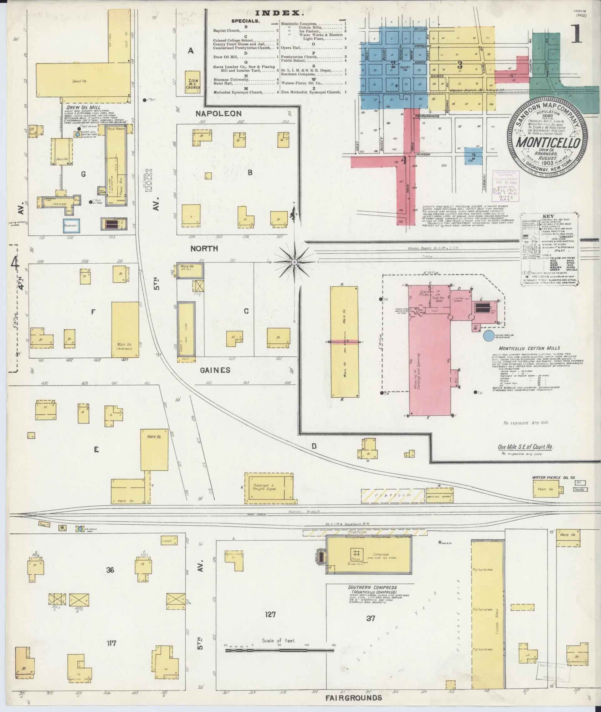
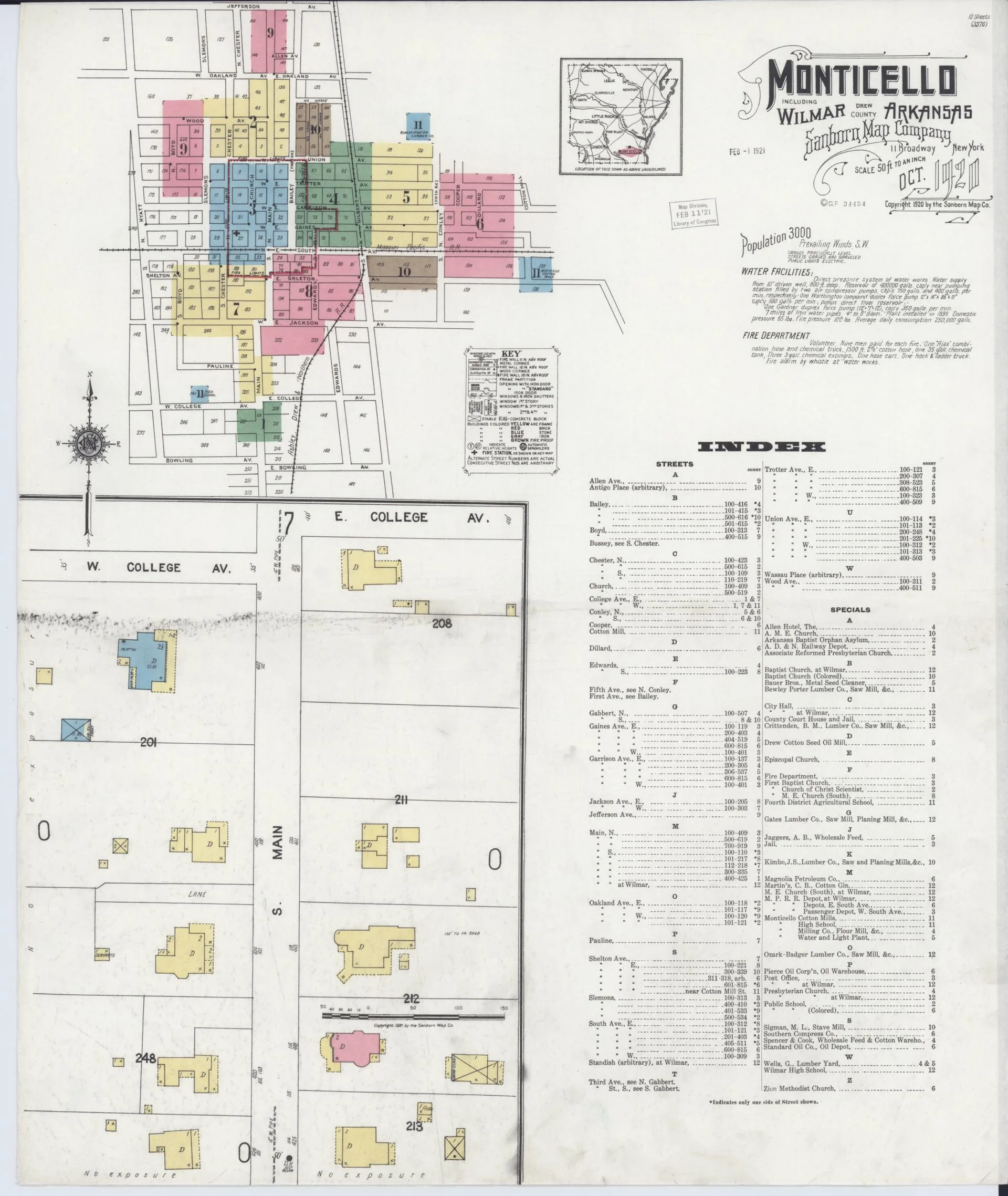
Sanborn fire insurance maps show Monticello building by building: pink for brick, yellow for frame. Here is the first sheet of each edition in the Library of Congress collection, from 1886 to 1920, followed by a recent photo. Swipe or scroll sideways to see them all, and select a map to open it full size.
April 1886

May 1891

February 1897

August 1903
May 1908

July 1912

October 1920
Now, 2014

Business and industry
- Cotton and banking: Goodspeed’s 1890 county history reports that 14,000 bales from the 1889 cotton crop were shipped from Monticello, and describes the Bank of Monticello as “the only bank in Southeast Arkansas” at the time. Goodspeed, Biographical and Historical Memoirs of Southern Arkansas (1890)
- County fair: The Agricultural and Mechanical Fair Association of Southeast Arkansas had its grounds at Monticello and held a fair there in October 1889, according to Goodspeed. Goodspeed, Biographical and Historical Memoirs of Southern Arkansas (1890)
- Oil mill and cotton mill: In October 1901 The Monticellonian reported that the Monticello Oil Mill had begun operating and that the output of the new Anderson Cotton Mill was already spoken for. By mid-November the paper described the cotton mill as just completed, with 5,000 spindles planned and an 825-foot well. The Monticellonian, Nov. 15, 1901 (Library of Congress)
Landmarks
- Drew County Courthouse, 210 S. Main St.: Built in 1932 to plans by architect H. Ray Burks, with Art Deco styling in its National Register record. It is the county’s fourth courthouse. Listed on the National Register in 1997. National Register file
- Monticello Commercial Historic District: The downtown blocks around the old courthouse square, with brick commercial buildings dating from about 1890 to 1961. Listed in 2011. National Register file
- Monticello Post Office, 211 W. Gaines St.: A 1937 Art Deco post office with a 1941 terra cotta sculpture by Berta Margoulies. Listed in 1998. National Park Service
- Ridgeway Hotel Historic District, 200–206 E. Gaines St.: The five-story Ridgeway Hotel, the tallest building downtown, and two neighboring commercial buildings. Its National Register file ties them to the town’s commercial growth during the Great Depression. Listed in 2009. National Park Service
- Rough and Ready Cemetery, about 1 mile southeast of the Monticello Civic Center on Arkansas 19: The only surviving trace of Rough and Ready, the county’s first seat. The first known burial was in 1847. Listed in 1999. National Park Service
- Monticello North Main Street Historic District: Blocks along North Main Street and Westwood Avenue. Listed in 1979. National Park Service
- Historic houses: Hotchkiss House, 509 N. Boyd St. (listed 1976); Garvin Cavaness House, 404 S. Main St. (1980); Robert Lee Hardy House, 207 S. Main St. (1982); Lambert House, 204 W. Jackson St. (1983). National Register database
- St. Mary's Episcopal Church, 115 S. Main St.: Listed on the National Register in 1996. National Park Service
- UAM campus: Harris and Horsfall halls (dedicated 1932, listed 2026), the Fine Arts Building (completed 1935, listed 2025), the Science Building (completed 1940, listed 2021), the Student Union (completed 1952, listed 2021) and the Fourth District Faculty House (listed 2022). UAM timeline
- Monticello Confederate Monument, Oakland Cemetery: Listed on the National Register in 1996. National Park Service
Notable people
- John Shirley Wood (1888–1966): Born in Monticello. As an Army major general he trained the 4th Armored Division and led it across France in 1944. Syracuse University Libraries
- Rodney Shelton Foss (1919–1941): Born in Monticello. Navy ensign killed at Kaneohe Bay, Hawaii, on Dec. 7, 1941. The destroyer escort USS Foss was named for him. Naval History and Heritage Command
- William Frank Norrell (1896–1961): Born in Milo, Ashley County. He studied at the A&M college in Monticello, practiced law in town and served in the U.S. House from 1939 until his death in 1961. He is buried in Oakland Cemetery. U.S. House History
- Catherine Dorris Norrell (1901–1981): Went to high school in Monticello and directed the music department at Arkansas A&M. After her husband’s death she won a special election on April 18, 1961, and served in Congress until January 1963. She later served as a deputy assistant secretary of state. U.S. House History
- William Ferguson Slemons (1830–1918): Practiced law in Monticello from 1855, served in the U.S. House from 1875 to 1881 and was Drew County judge from 1903 to 1907. He died in Monticello in 1918. U.S. House History
- Hershel Wayne Gober: Born in Monticello on Dec. 21, 1936. He directed Arkansas’s veterans affairs department and later served as deputy U.S. secretary of veterans affairs, twice acting as secretary. Encyclopedia of Arkansas
Last checked Oct. 18, 2026.
Key facts
- Monticello is the county seat of Drew County, which the Arkansas Legislature created on Nov. 26, 1846. (Source: National Register nomination, Drew County Courthouse (Arkansas Historic Preservation Program))
- The University of Arkansas at Monticello began as the Fourth District Agricultural School, created by the Legislature in 1909. Classes began Sept. 14, 1910. (Source: University of Arkansas at Monticello)
- Downtown Monticello around the old courthouse square was listed on the National Register of Historic Places in 2011 as the Monticello Commercial Historic District. (Source: National Park Service)
- The Equal Justice Initiative documents 8 racial terror lynchings of Black people in Drew County between 1877 and 1950. EJI counts only cases it could document, so the figure is a minimum. (Source: Equal Justice Initiative, Lynching in America county data (updated November 2024))
- Monticello shipped 14,000 bales of cotton from the 1889 crop, according to Goodspeed's 1890 county history. (Source: Goodspeed, Biographical and Historical Memoirs of Southern Arkansas (1890))
Timeline
Drew County is created
On Nov. 26 the Arkansas Legislature creates Drew County from part of Bradley County and names it for Gov. Thomas S. Drew.
First county court meets
The first county court meets on March 22 at the home of Alexander M. Rawles. The oldest known burial at Rough and Ready Cemetery also dates to 1847.
Court meets at Rough and Ready
Court meets at the Rodgers School in Rough and Ready, a hilltop village about a mile south of today's downtown.
1849–1851
Monticello is laid out
Commissioners pick a permanent county seat. Fountain C. Austin deeds an 83-acre tract, and a town said to be named for Thomas Jefferson's Virginia home is laid out on a grid around a courthouse square. Court first meets in Monticello in October 1850.
1851–1871
Three courthouses on the square
The county builds three courthouses on the square: a frame building in 1851, a second in 1856–57, and a brick courthouse with a 110-foot clock tower in 1870–71.
1880s
The railroad arrives
Monticello's first railroad arrives, running east and west one block south of the square.
Sanborn map of downtown
A Sanborn fire insurance map of Monticello is drawn, showing the courthouse in the middle of the square (see the photos above).
14,000 bales
Monticello ships 14,000 bales from the 1889 cotton crop, according to Goodspeed's 1890 county history, which also calls the Bank of Monticello "the only bank in Southeast Arkansas."
Fifteenth annual fair
The Agricultural and Mechanical Fair Association of Southeast Arkansas holds its 15th annual fair at Monticello. Its district covers 11 Arkansas counties and four Louisiana parishes, according to Goodspeed.
Telephone to Hamburg
A telephone line links Monticello with Hamburg, according to Goodspeed.
Oil mill and cotton mill
The Monticello Oil Mill begins operating in October, and the new Anderson Cotton Mill is completed that fall, according to The Monticellonian.
1909–1910
Agricultural school opens
The Legislature creates the Fourth District Agricultural School on April 1, 1909. The board picks Monticello, on land offered by the family of Judge William Turner Wells, and classes begin on Sept. 14, 1910.
A second railroad
A second railroad, the Ashley, Drew and Northern, reaches town, running north and south a few blocks east of the square.
1925–1939
The college gets new names
The agricultural school is renamed the Agricultural and Mechanical College of the Fourth District in 1925 and Arkansas A&M College in 1939.
Flood refugee camps
During the Mississippi River flood of 1927, the Red Cross runs separate refugee camps at Monticello for white and Black flood victims, according to photograph records at the Butler Center for Arkansas Studies.
New courthouse on South Main
The old courthouse on the square is torn down. A new limestone courthouse designed by architect H. Ray Burks opens two blocks south at 210 S. Main St.
Post office opens
The Art Deco post office opens on West Gaines Street. A terra cotta sculpture by Berta Margoulies, paid for through a federal arts program, is added in 1941.
Rodney Foss killed at Kaneohe Bay
On Dec. 7, Ensign Rodney Shelton Foss, born in Monticello, is killed at Naval Air Station Kaneohe Bay, Hawaii, during the Japanese attack. The Navy later names the destroyer escort USS Foss for him.
1942–1944
Jerome War Relocation Center
During World War II the federal War Relocation Authority holds incarcerated Japanese Americans at the Jerome War Relocation Center in southeastern Drew and Chicot counties, whose post office was called Denson. The camp opens Oct. 6, 1942, and holds as many as 8,497 people, most from California and 811 from Hawaii. It is the last of the 10 camps to open and, in June 1944, the first to close. Arkansas's other camp, Rohwer, was in Desha County. After Jerome closed, the site became Camp Dermott, a prisoner-of-war camp for German soldiers, which opened in October 1944, according to the Densho Encyclopedia.
1963–1964
Fires on the square
Two fires change the square. On Dec. 12, 1963, fire destroys two buildings on the east side. On Jan. 23, 1964, fire destroys five of the seven two-story Italianate buildings on the south side.
Arkansas A&M becomes UAM
Arkansas A&M College joins the University of Arkansas System on July 1 and becomes the University of Arkansas at Monticello.
Downtown joins the National Register
The downtown blocks around the old square are listed on the National Register of Historic Places as the Monticello Commercial Historic District.
Photos
Sanborn fire insurance map of downtown Monticello. The county courthouse stands in the center of the square. Photo: Library of Congress, Geography and Map Division, Sanborn Maps Collection, April 1886. Public domain (per Library of Congress). Source 
Campus of the Fourth District Agricultural School, the school that became UAM. The red number is a printer's archive mark. Photo: Curt Teich & Co. postcard A19256, Newberry Library, Curt Teich Postcard Archives, 1910s. No known copyright (per Newberry Library, Teich postcards printed before 1964). Source 
John Shirley Wood, born in Monticello in 1888, in his West Point yearbook portrait. Photo: The Howitzer, 1912 (U.S. Military Academy yearbook), p. 142, via Wikimedia Commons, 1912. Public domain (per HathiTrust rights record). Source 
Drew County Courthouse, 210 S. Main St., built in 1932. Photo: Brandonrush, Wikimedia Commons, May 15, 2014. CC BY-SA 3.0. Source 
The 1937 Art Deco post office on West Gaines Street. Photo: Brandonrush, Wikimedia Commons, May 15, 2014. CC BY-SA 3.0. Source 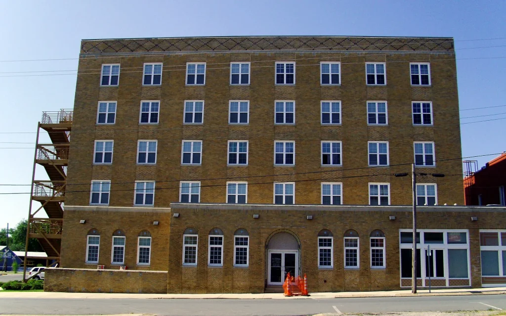
The Ridgeway Hotel on East Gaines Street, the tallest building downtown. Photo: Brandonrush, Wikimedia Commons, May 15, 2014. CC BY-SA 3.0. Source 
The Fine Arts Building at UAM, completed in 1935. Photo: UAMonticello, Wikimedia Commons, Nov. 18, 2015. CC BY-SA 4.0. Source 
Rough and Ready Cemetery, the last trace of the county's first seat. Photo: Valis55, Wikimedia Commons, Nov. 26, 2016. CC BY-SA 4.0. Source 
Storefronts in the Monticello Commercial Historic District. Photo: Brandonrush, Wikimedia Commons, May 14, 2014. CC BY-SA 3.0. Source The old courthouse square is now a small park with a fountain. Photo: Brandonrush, Wikimedia Commons, May 15, 2014. CC BY-SA 3.0. Source 
The May 1891 Sanborn fire insurance map of Monticello, a single sheet. Photo: Library of Congress, Geography and Map Division, Sanborn Maps Collection, May 1891. Public domain (per Library of Congress). Source 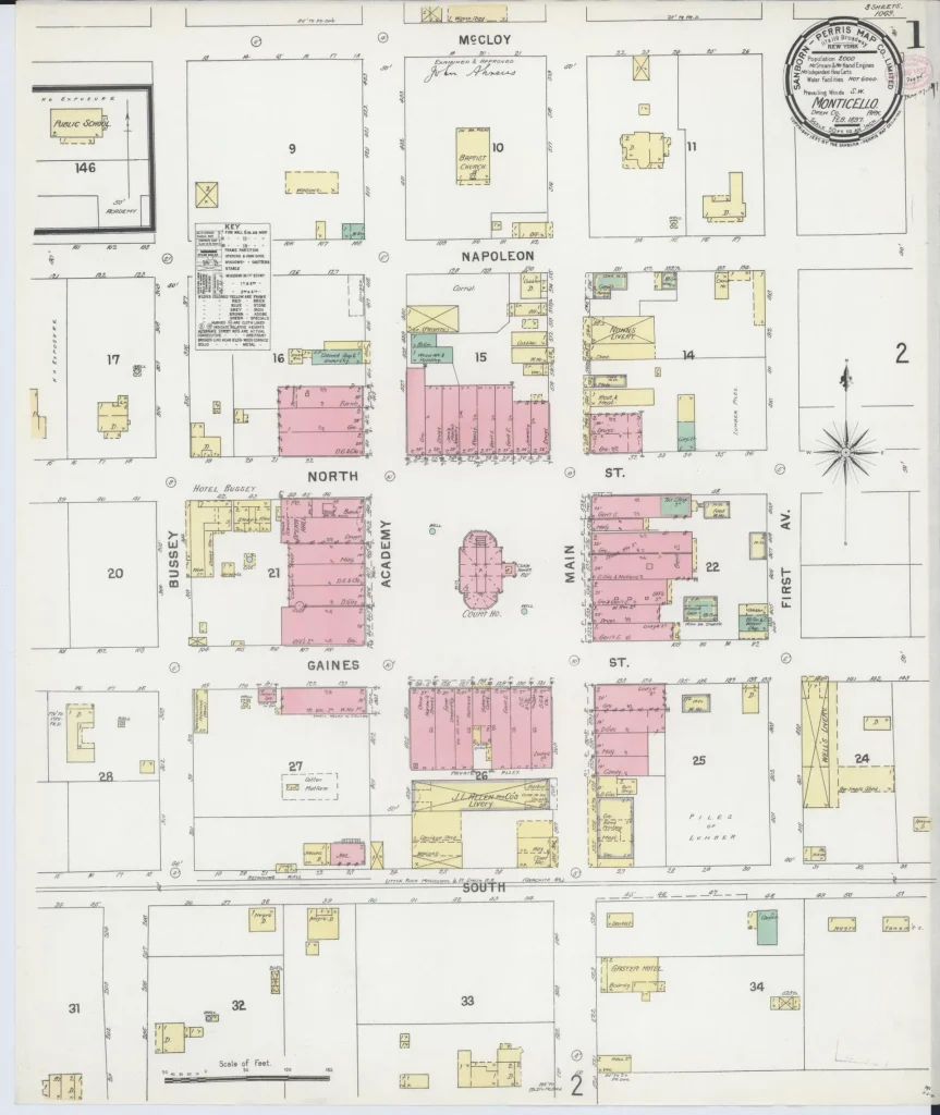
Sheet 1 of the February 1897 Sanborn fire insurance map of Monticello (3 sheets). Photo: Library of Congress, Geography and Map Division, Sanborn Maps Collection, February 1897. Public domain (per Library of Congress). Source 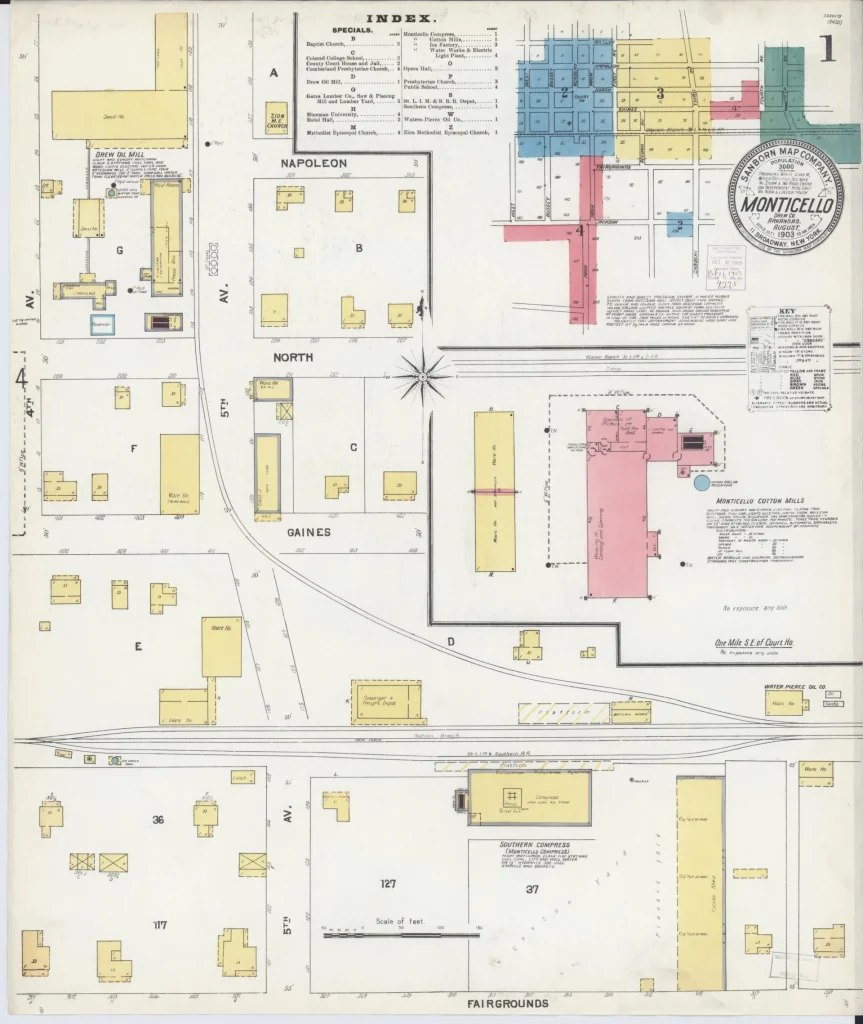
Sheet 1 of the August 1903 Sanborn fire insurance map of Monticello (5 sheets). Photo: Library of Congress, Geography and Map Division, Sanborn Maps Collection, August 1903. Public domain (per Library of Congress). Source 
Sheet 1 of the May 1908 Sanborn fire insurance map of Monticello (6 sheets). Photo: Library of Congress, Geography and Map Division, Sanborn Maps Collection, May 1908. Public domain (per Library of Congress). Source 
Sheet 1 of the July 1912 Sanborn fire insurance map of Monticello (8 sheets). Photo: Library of Congress, Geography and Map Division, Sanborn Maps Collection, July 1912. Public domain (per Library of Congress). Source 
Sheet 1 of the October 1920 Sanborn fire insurance map of Monticello (12 sheets). Photo: Library of Congress, Geography and Map Division, Sanborn Maps Collection, October 1920. Public domain (per Library of Congress). Source
_at_West_Point_in_1912.png)


Sources
- Drew County Courthouse, National Register nomination (1997), Arkansas Historic Preservation Program. Accessed .
- Monticello Commercial Historic District, National Register nomination (2011), Arkansas Historic Preservation Program. Accessed .
- Rough and Ready Cemetery (NRIS 99001376), National Park Service, NPGallery. Accessed .
- Monticello Post Office (NRIS 98000920), National Park Service, NPGallery. Accessed .
- Ridgeway Hotel Historic District (NRIS 08000952), National Park Service, NPGallery. Accessed .
- UAM History, University of Arkansas at Monticello. Accessed .
- Foss (DE-59), Naval History and Heritage Command. Accessed .
- NORRELL, William Frank, U.S. House of Representatives: History, Art & Archives. Accessed .
- NORRELL, Catherine Dorris, U.S. House of Representatives: History, Art & Archives. Accessed .
- SLEMONS, William Ferguson, U.S. House of Representatives: History, Art & Archives. Accessed .
- John Shirley Wood Papers, Syracuse University Libraries. Accessed .
- War Relocation Centers, National Park Service. Accessed .
- Confinement and Ethnicity: An Overview of World War II Japanese American Relocation Sites, Chapter 7: Jerome Relocation Center, National Park Service (Burton et al., 1999). Accessed .
- Jerome (Brian Niiya), Densho Encyclopedia. Accessed .
- Aerial views of the 1927 flood refugee camps at Monticello (records 29573 and 29688), Butler Center for Arkansas Studies, Arkansas Studies Research Portal. Accessed .
- Monticello (Drew County), Encyclopedia of Arkansas. Accessed .
- Lynching in America: county data supplement (updated November 2024), Equal Justice Initiative. Accessed .
- Sanborn Fire Insurance Map from Monticello, Drew County, Arkansas, April 1886, Library of Congress. Accessed .
- Campus 4th District Agricultural School (postcard A19256), Newberry Library, Curt Teich Postcard Archives. Accessed .
- Biographical and Historical Memoirs of Southern Arkansas, vol. 2 (Goodspeed Publishing, 1890), Internet Archive. Accessed .
- The Monticellonian, Oct. 4, 1901, page 3, Library of Congress, Chronicling America. Accessed .
- The Monticellonian, Nov. 15, 1901, page 2, Library of Congress, Chronicling America. Accessed .