Floods, tornadoes, ice storms and droughts that struck Drew, Bradley, Desha, Lincoln, Ashley, Chicot, Dallas and Cleveland counties, starting with the Great Flood of 1927.
Updated Oct. 18, 2026.
The Great Flood of 1927
In the spring of 1927, the Mississippi River rose to a level it has never matched since at Arkansas City. On April 21 it crested at 59.2 feet on the gauge there, more than 22 feet above today’s flood stage.
The National Weather Service says the flood reached 36 of Arkansas’s 75 counties and hit Arkansas harder than any other state in the valley. With the Mississippi so high, the Arkansas and White rivers could not drain and backed up across the land.
Photographs from that spring, now at the Library of Congress, show the fight and its toll. On April 22, crews stacked sacks on the levee at Lakeport in Chicot County. Two weeks later, at Arkansas City, people were living in a tent camp on the levee.
How much water passed Arkansas City is still uncertain. The U.S. Geological Survey’s estimate is 2,470,000 cubic feet per second, but its own review found no direct measurement and no record of the exact day.
The flood changed federal law. The Flood Control Act, approved May 15, 1928, adopted the Army Chief of Engineers’ plan to control floods on the lower Mississippi and authorized $325 million to carry it out.
Photos

Refugee camp on the levee at Arkansas City, May 6, 1927. Photo: Library of Congress, Prints and Photographs Division, May 6, 1927. No known restrictions on publication. Source 
Refugee camp at Arkansas City, May 5, 1927. A note with the original print reads "Ark. City gage, 49.7." Photo: Library of Congress, Prints and Photographs Division, May 5, 1927. No known restrictions on publication. Source 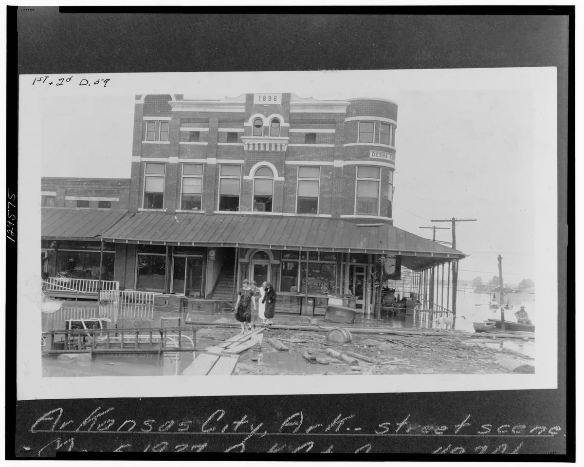
Street scene in Arkansas City, May 5, 1927. A note with the original print reads "Ark. City Gage 49.7 ft." Photo: Library of Congress, Prints and Photographs Division, May 5, 1927. No known restrictions on publication. Source 
Looking south along the levee at Lakeport in Chicot County from a dragline cab, April 22, 1927. Photo: Library of Congress, Prints and Photographs Division, April 22, 1927. No known restrictions on publication. Source
Key facts
- The Mississippi crested at 59.2 feet near Arkansas City on April 21, 1927. No crest there since has been higher, according to the National Weather Service. Flood stage is 37 feet. (Source: National Weather Service)
- The National Weather Service says the 1927 flood reached 36 of Arkansas's 75 counties and that Arkansas suffered more, in lives and money, than any other state in the Mississippi Valley. (Source: National Weather Service)
- USGS estimates the 1927 peak flow near Arkansas City at 2,470,000 cubic feet per second, but a USGS review found no direct measurement of it and could not pin down the day. (Source: U.S. Geological Survey)
- Congress responded with the Flood Control Act, approved May 15, 1928, which authorized $325 million for flood control on the Mississippi and its tributaries. (Source: U.S. Statutes at Large (45 Stat. 534))
- The deadliest tornado in these eight counties in NOAA's records since 1950 was an F4 in Bradley County on March 28, 1975: 7 deaths and 51 injuries. (Source: NOAA Storm Events Database)
- An EF3 tornado crossed the southeast side of Dumas on Feb. 24, 2007. NOAA lists 28 injuries, no deaths and $45 million in property damage in Desha County. (Source: NOAA Storm Events Database)
Tornadoes, ice and drought since 1950
The tables below come from NOAA’s Storm Events Database, which has listed tornadoes since 1950 and all types of storms since 1996. Each row has a NOAA event number you can look up in the database. Counts of deaths and injuries are NOAA’s. This page does not name victims.
Some records are rough. NOAA logs early tornadoes by county, so a long tornado can show up as more than one row, and damage figures before 1996 are broad ranges, so we leave them out.
Data
| Measure | Value | Source |
|---|---|---|
| Highest crest (National Weather Service list) | 59.2 feet on April 21, 1927 | NWS, Arkansas City gauge |
| Flood stage at Arkansas City today | 37 feet | NWS, Arkansas City gauge |
| Highest gage height in USGS peak record for 1927 | 60.4 feet on April 21, 1927 | USGS site 07265450 |
| Estimated peak flow | 2,470,000 cubic feet per second, May 1927 (estimate) | USGS site 07265450 |
| Arkansas counties affected | 36 of 75 | NWS, Flooding in Arkansas |
| Federal response | Flood Control Act, approved May 15, 1928; authorized $325,000,000 | 45 Stat. 534 |
Source: National Weather Service; U.S. Geological Survey; U.S. Statutes at Large. Updated .
| Date | County | Rating | Path length listed (miles) | Deaths | Injuries | NOAA event no. |
|---|---|---|---|---|---|---|
| Oct. 28, 1955 | Desha | F3 | 1 | 0 | 1 | 9984208 |
| May 23, 1957 | Drew | F3 | 5.2 | 0 | 0 | 9984268 |
| Feb. 9, 1965 | Bradley | F3 | 1.5 | 0 | 1 | 9983199 |
| April 3, 1968 | Lincoln | F4 | 33.7 | 5 | 16 | 9982104 |
| June 20, 1972 | Bradley | F3 | 0.3 | 0 | 0 | 9984429 |
| March 28, 1975 | Bradley | F4 | 5.4 | 7 | 51 | 9981644 |
| Feb. 17, 1976 | Ashley | F2 | 7.6 | 3 | 10 | 9980316 |
| March 20, 1976 | Chicot | F3 | 2.3 | 0 | 0 | 9980340 |
| April 8, 1979 | Bradley | F3 | 14 | 0 | 0 | 9982389 |
| April 8, 1979 | Ashley | F3 | 17.7 | 0 | 13 | 9982394 |
| Oct. 22, 1979 | Chicot | F1 | 1.5 | 1 | 2 | 9981290 |
| Oct. 17, 1980 | Drew | F2 | 1.5 | 1 | 2 | 9979974 |
| March 14, 1990 | Dallas | F2 | 2 | 1 | 6 | 9990991 |
| May 27, 1996 | Dallas | F3 | 15 | 0 | 0 | 5554187 |
| Jan. 21, 1999 | Dallas | F3 | 11 | 0 | 0 | 5684583 |
| Feb. 24, 2001 | Desha | F3 | 42 | 0 | 0 | 5233460 |
| Nov. 24, 2001 | Ashley | F3 | 13 | 3 | 11 | 5272442 |
| Feb. 24, 2007 | Desha | EF3 | 18.1 | 0 | 28 | 18599 |
Source: NOAA National Centers for Environmental Information, Storm Events Database. Updated .
| Dates | Counties listed | Property damage listed, by county | NOAA event no. |
|---|---|---|---|
| Dec. 22, 1998 to Dec. 24, 1998 | Ashley, Bradley, Chicot, Cleveland, Dallas, Desha, Drew, Lincoln | Ashley $900,000; Chicot $900,000 | 5677869 and 7 more |
| Dec. 13, 2000 | Ashley, Chicot | Ashley $10,000; Chicot $5,000 | 5176880 and 1 more |
| Dec. 25, 2000 to Dec. 28, 2000 | Bradley, Cleveland, Dallas, Desha, Drew, Lincoln | None listed | 5168829 and 10 more |
| Feb. 25, 2003 to Feb. 26, 2003 | Ashley, Bradley, Chicot, Cleveland, Dallas, Desha, Drew, Lincoln | Ashley $50,000; Chicot $50,000 | 5342926 and 7 more |
| Jan. 25, 2008 | Ashley, Chicot | Ashley $200,000; Chicot $200,000 | 76733 and 1 more |
| Feb. 4, 2011 | Chicot | Chicot $100,000 | 291178 |
| Jan. 14, 2013 to Jan. 15, 2013 | Ashley, Chicot | Ashley $25,000; Ashley $10,000; Chicot $75,000; Chicot $25,000 | 424683 and 3 more |
| Feb. 11, 2014 to Feb. 12, 2014 | Ashley, Chicot | None listed | 493633 and 1 more |
| Feb. 16, 2015 | Cleveland, Dallas, Lincoln | Cleveland $75,000; Dallas $75,000; Lincoln $75,000 | 558556 and 2 more |
| Feb. 11, 2021 | Drew | None listed | 946388 |
| Jan. 31, 2023 | Cleveland, Lincoln | None listed | 1078458 and 1 more |
| Feb. 1, 2023 to Feb. 2, 2023 | Bradley, Cleveland, Dallas, Drew | None listed | 1080706 and 6 more |
| Jan. 9, 2025 to Jan. 10, 2025 | Drew, Lincoln | None listed | 1246991 and 1 more |
Source: NOAA National Centers for Environmental Information, Storm Events Database. Updated .
| Period | Months | Counties listed |
|---|---|---|
| September 2000 | 1 | Bradley, Cleveland, Dallas, Desha, Drew, Lincoln |
| October 2006 | 1 | Ashley, Chicot |
| July 2010 to November 2011 | 17 | Ashley, Bradley, Chicot, Cleveland, Dallas, Desha, Drew, Lincoln |
| June 2012 to November 2012 | 6 | Bradley, Cleveland, Dallas, Desha, Drew, Lincoln |
| July 2013 to October 2013 | 4 | Bradley, Cleveland, Dallas, Desha, Drew, Lincoln |
| September 2015 to October 2015 | 2 | Ashley, Chicot |
| November 2016 to December 2016 | 2 | Ashley, Chicot |
| November 2017 | 1 | Ashley, Bradley, Cleveland, Dallas, Drew, Lincoln |
| October 2023 to November 2023 | 2 | Ashley, Chicot |
| May 2026 to June 2026 | 2 | Ashley, Chicot |
Source: NOAA National Centers for Environmental Information, Storm Events Database. Updated .
Timeline
Mississippi crests at Arkansas City
The river reaches 59.2 feet, still the record on the National Weather Service list.
Crews hold the levee at Lakeport
Library of Congress photos from this day show sandbagging on the Chicot County levee.
Refugee camp on the Arkansas City levee
Photos from May 5 and 6 show tents on the levee; a note on one print gives the gauge at 49.7 feet.
Flood Control Act approved
Congress authorizes $325 million for Mississippi River flood control.
F4 tornado in Lincoln County
NOAA lists 5 deaths and 16 injuries.
F4 tornado in Bradley County
NOAA lists 7 deaths and 51 injuries, the most in these counties since 1950.
Ice storm across all eight counties
NOAA logs ice in every county through Dec. 24.
F3 tornado near Wilmot
NOAA lists 3 deaths and 11 injuries in Ashley County.
EF3 tornado hits Dumas
NOAA lists 28 injuries and $45 million in damage.
Long drought begins
NOAA lists drought in parts of the region in every month through November 2011.
Mississippi crests at 53.14 feet
The highest at Arkansas City since 1937, per the National Weather Service list.
For more of the history, read the Encyclopedia of Arkansas entry on the Flood of 1927. River crests and flows for the Mississippi, Saline, Ouachita and Bayou Bartholomew are on our river history pages.
Sources
- Flooding in Arkansas: The Great Flood of 1927, National Weather Service. Accessed .
- Mississippi River at Arkansas City (ARSA4): flood categories and historic crests, National Weather Service / NOAA. Accessed .
- Historic Mississippi River flooding (2011 crests and 1927 records), National Weather Service, Jackson, Miss.. Accessed .
- Peak streamflow, Mississippi River near Arkansas City (07265450), U.S. Geological Survey. Accessed .
- Scientific Investigations Report 2008-5164: review of the May 1927 peak at Arkansas City, U.S. Geological Survey. Accessed .
- An Act for the control of floods on the Mississippi River (May 15, 1928), 45 Stat. 534, U.S. Government Publishing Office. Accessed .
- Storm Events Database, NOAA National Centers for Environmental Information. Accessed .
- Storm Events bulk data files (1950-2026), NOAA National Centers for Environmental Information. Accessed .
- Flood photographs, Mississippi River and tributaries, high water 1927 (LOT 3375-2), Library of Congress. Accessed .
- Flood of 1927, Encyclopedia of Arkansas. Accessed . Further reading; not used as a source for figures.
- Dumas (Desha County), Encyclopedia of Arkansas. Accessed . Further reading; not used as a source for figures.